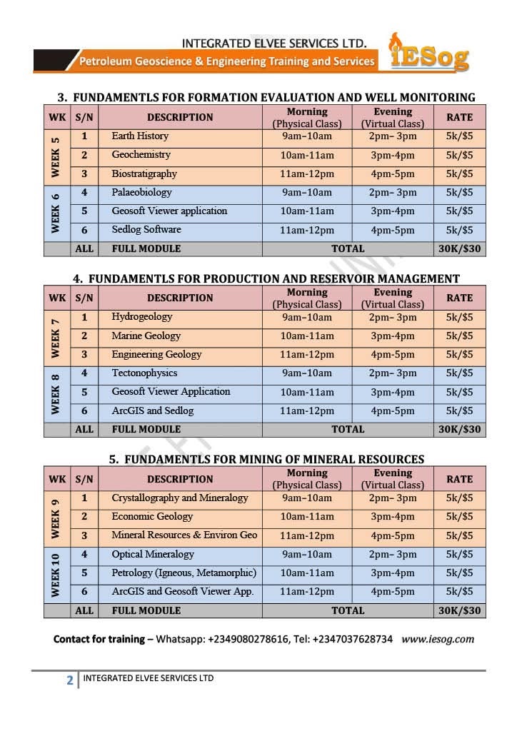
Elvee School of Geoscience and Mining Training: 04 August to 8 August 2025 / Physical: 9am to 12noon & Virtual: 2pm to 5pm daily by Zoom (WAT / UTC+1)OPTICAL MINERALOGY
* Properties of Light, Polarizing Microscope, Double Refraction
* Refractive Index and Relief, Uniaxiality and biaxiality of crystals
* Optical, Isotropic Indicatrix, Uniaxial and Biaxial Indicatrix
* Properties of Minerals / Optical Mineralogy
* Polarized, Cross-Polarized, and Convergent Polarized Light
* Determination of Optic Sign and Dispersion X-Ray Crystallography
PETROLOGY OF IGNOUS AND METAMORPHIC ROCKS
* Magma, Volcanoes and their Products, Volcanoes, Volcanic Products
* Igneous Rocks, Classes: Ultrabasic Rocks, Basic Rocks, Intermediate Rocks, Acid Rocks, Alkaline Rocks
* Metamorphism: Regional, Contact and Dislocation Metamorphism
* Facies and Migmatites, Anatexia, Zones of Metamorphism
* Petrographic Study and Petrogenesis, Phase Rule and Thermodynamic Principles, Stability Fields
* Crystallization of Silicate Melts, One and Two-Component Systems
* Eutectic, Peritectic and Solid Solution Series, Reaction Principles, Mineral Paragenesis
* Instrumental Analysis of Minerals and methods of Normative Mineral Calculation
* Distribution and Genetic Relationship of Igneous and Metamorphic Rocks
GEOSOFT VIEWER APPLICATION (OASIS MONTAJ)
* Introduction to Oasis Montaj: Viewer Application, Menu and Functionalities, New Project
* Data Management and Organization: Importing Data, Coordinates, Filtering, Processing
* Data Visualization and Interpretation: Gridding, Imaging, Plotting, Interpreting Anomalies
* Exporting and Reporting: Export Data, Formats, Reports, Integration with Other Data
* Practical Exercises, Hands-On Practice: Importing and Processing Data Using the Software
ARCGIS SOFTWARE
* Introduction to ArcGIS: Data Required, Starting a new Project
* Data Organization: Add and Set Data Frame Properties, Define the Coordinate System, Customize ArcMap Options, Georeference Maps, Update Georeferencing
* Dealing with Database: Personal Geodatabase, Dataset, Feature Classes, Attributes
* Digital Elevation Model (DEM): Extraction of Study Area, Display
* Map Properties: Generate Contours, Grid, Legend, Scale Bar, Scale Text, North Arrow
* Display and Export: Layout, Export Data in Various Formats
THIS PREREQUISITE TRAINING CLOSES THE GAPS FOR MISSING FUNDAMENTALS IN FIRST DEGREE COURSES AND PREPARES CANDIDATES FOR PROFESSIONAL E&P SKILLS ACQUISITION
To participate, follow the instructions on the flyer and register on or before Monday, 04 August, 2025.
For more enquiries, WhatsApp: +2349080278616 or Call +2347037628734.