

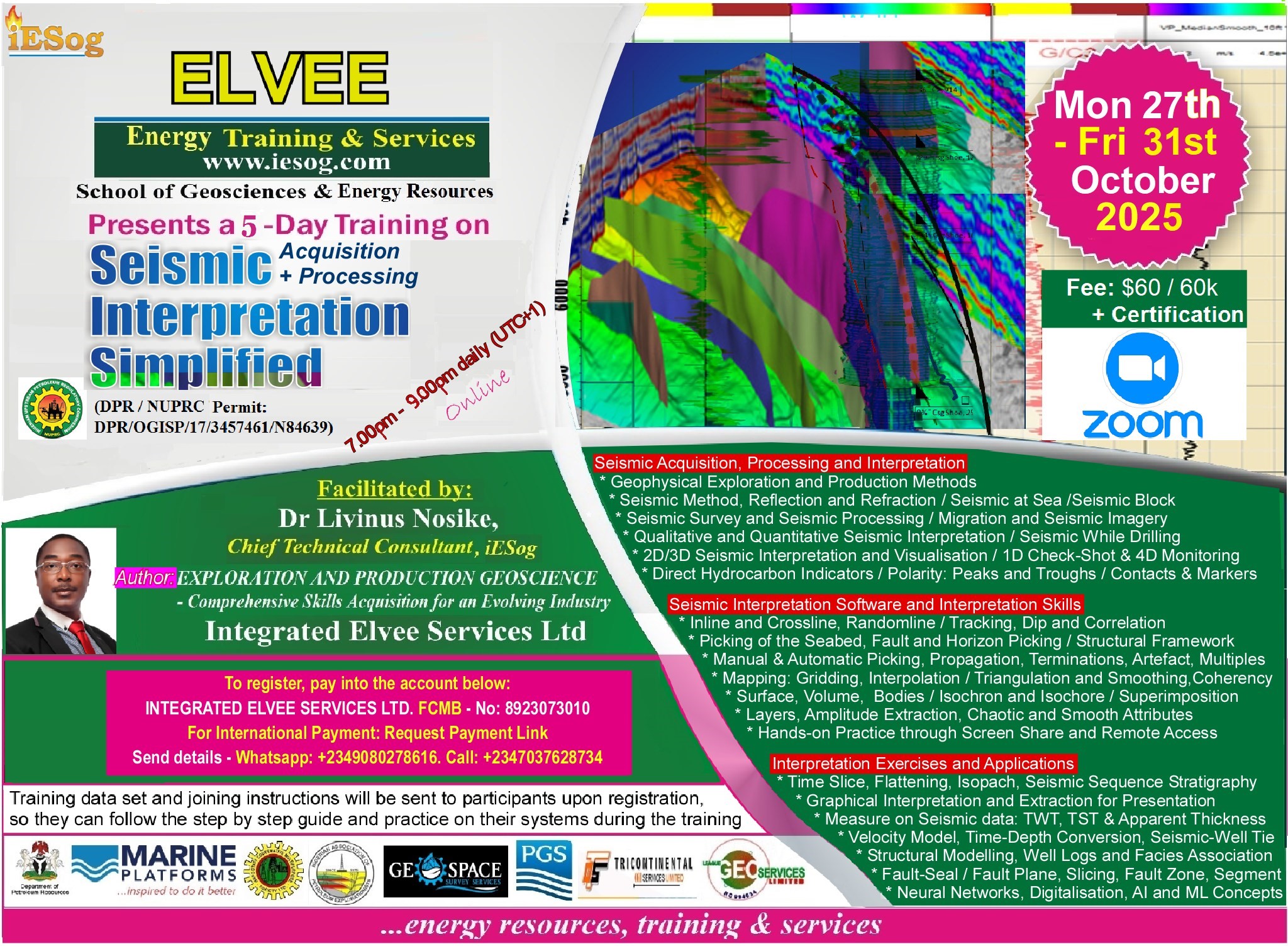
Elvee Energy Training: 27 Oct. to 31 Oct., 2025 / 7.00pm to 9.00pm daily (WAT/UTC+1)
This training will use classroom illustration and industry software to help participants acquire the following skills:
SEISMIC ACQUISITION, PROCESSING AND INTERPRETATION
* Geophysical Exploration and Production Methods
* Seismic Method, Reflection and Refraction / Seismic at Sea / Bathymetry
* Seismic Survey and Seismic Processing / Migration and Seismic Imagery
* Qualitative and Quantitative Seismic Interpretation / Seismic While Drilling
*2D/3D Seismic Interpretation and Visualisation / 1D Check-shot & 4D monitoring
* Direct Hydrocarbon Indicators / Polarity: Peaks and Troughs / Contacts & Markers
SEISMIC INTERPRETATION SOFTWARE AND INTERPRETATION SKILLS
* Inline and Crossline, Randomlines / Tracking, Dip and Correlation
* Picking of the Seabed, Faults and Horizons / Structural Framework
* Seismic Block, Gridding, Interpolation / Triangulation, Trimesh, Lines, Smoothing
* Surfaces and Volumes / Bodies, Isochron and Isochores / Superimposition
* Layers, Amplitude Extraction, Coherency, Terminations, and Attribute Maps
* Hands-on Practice through Screen Share and Remote Access
INTERPRETATION EXERCISES AND APPLICATION TO PROSPECT EVALUATION
* Time Slice, Horizon Flattening, Isopach, Geochronology / Seismic Sequence Stratigraphy
* Measurement on Seismic: TWT, TST and Apparent Thickness
* Velocity Model, Time to Depth Conversion, Seismic to Well Tie and Kriging
* Integration of Well Logs, Petrophysical and Facies Analysis on a Prospect
* Interpretation of Fault Plane, Fault Slicing and Fault Zone, Fault Segment
* Neural Networks, Digitalisation and Machine Learning Concepts
To participate, follow instructions on the flyer and register before the 27th of October, 2025.
For enquiries, whatsapp: +2349080278616 or Call +2347037628734.
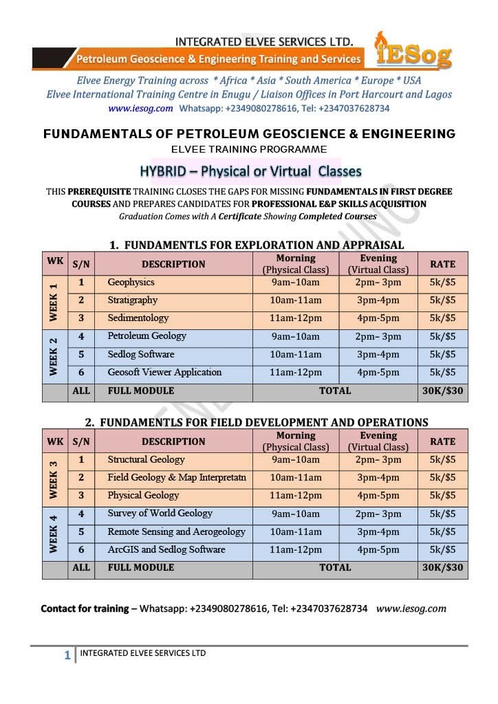


Elvee Energy Training: 27 to 31 October 2025 / Physical: 9am to 12noon & Virtual: 2pm to 5pm daily (Zoom: WAT / UTC+1)
SURVEY OF WORLD GEOLOGY
* Origin and Evolution of the Earth
* Structural Development and Major Tectonic Elements
* Major Tectonic Elements; Continental Drift, Seafloor Spreading
* Distribution of Igneous, Metamorphic and Sedimentary Rocks and Transitions
* Economic Geology of Selected Regions of the World
* Economic Mineral Deposits of the World
* Geologic Mapping and Development
REMOTE SENSING AND AEROGEOLOGY
* Introduction to Remote Sensing and Aerogeology
* Elements of Photogrammetry, Vertical or Normal, Oblique
* Photo Interpretation, Preparation of Photogeologic Maps and Techniques
* Satellite Data, Geographic Information System (GIS)
* Geologic Application of Remote Sensing and Aerogeology
ARCGIS SOFTWARE
* Introduction to ArcGIS: Data Required, Starting a new Project
* Data Organization: Add and Set Data Frame Properties, Define the Coordinate System, Customize ArcMap Options, Georeference Maps, Update Georeferencing
* Dealing with Database: Personal Geodatabase, Dataset, Feature Classes, Attributes
* Digital Elevation Model (DEM): Extraction of Study Area, Display
* Map Properties: Generate Contours,Grid, Legend, Scale Bar, Scale Text, North Arrow
* Display and Export: Layout, Export Data in Various Formats
SEDLOG SOFTWARE
Installation, coaching and hands-on Practice: participants will practice creating and customizing graphic logs using real or simulated data.
THIS PREREQUISITE TRAINING CLOSES THE GAPS FOR MISSING FUNDAMENTALS IN FIRST DEGREE COURSES AND PREPARES CANDIDATES FOR PROFESSIONAL E&P SKILLS ACQUISITION
To participate, follow the instructions on the flyer and register on or before Monday, 27 October, 2025.
For more enquiries, WhatsApp: +2349080278616 or Call +2347037628734.