

Elvee Energy Training: 23 to 27 June 2025 / Physical: 9am to 12noon & Virtual: 2pm to 5pm daily (Zoom: WAT / UTC+1)
SURVEY OF WORLD GEOLOGY
* Origin and Evolution of the Earth
* Structural Development and Major Tectonic Elements
* Major Tectonic Elements; Continental Drift, Seafloor Spreading
* Distribution of Igneous, Metamorphic and Sedimentary Rocks and Transitions
* Economic Geology of Selected Regions of the World
* Economic Mineral Deposits of the World
* Geologic Mapping and Development
REMOTE SENSING AND AEROGEOLOGY
* Introduction to Remote Sensing and Aerogeology
* Elements of Photogrammetry, Vertical or Normal, Oblique
* Photo Interpretation, Preparation of Photogeologic Maps and Techniques
* Satellite Data, Geographic Information System (GIS)
* Geologic Application of Remote Sensing and Aerogeology
ARCGIS SOFTWARE
* Introduction to ArcGIS: Data Required, Starting a new Project
* Data Organization: Add and Set Data Frame Properties, Define the Coordinate System, Customize ArcMap Options, Georeference Maps, Update Georeferencing
* Dealing with Database: Personal Geodatabase, Dataset, Feature Classes, Attributes
* Digital Elevation Model (DEM): Extraction of Study Area, Display
* Map Properties: Generate Contours,Grid, Legend, Scale Bar, Scale Text, North Arrow
* Display and Export: Layout, Export Data in Various Formats
SEDLOG SOFTWARE
Installation, coaching and hands-on Practice: participants will practice creating and customizing graphic logs using real or simulated data.
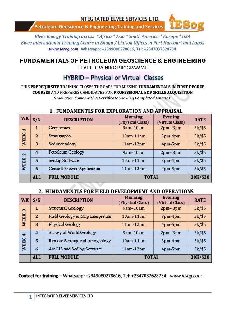
THIS PREREQUISITE TRAINING CLOSES THE GAPS FOR MISSING FUNDAMENTALS IN FIRST DEGREE COURSES AND PREPARES CANDIDATES FOR PROFESSIONAL E&P SKILLS ACQUISITION
To participate, follow the instructions on the flyer and register on or before Monday, 23 June, 2025.
For more enquiries, WhatsApp: +2349080278616 or Call +2347037628734.