

Our Short Courses on E&P Disciplines cover the exploration process, oil fields prospecting, assessment of reserves, prospect evaluation, seal analyses and how to go from exploration to production. Click to see the course modules and read more.
Aims of exploration geology and geophysics
Exploration geology and geophysics has wide applications worldwide. In the oil and gas industry, geologic and geophysical principle is used to find new petroleum reserves that can be exploited. This is done by searching for new sedimentary basins where there is an oil pool, and sometimes existing petroleum fields for not yet discovered levels or hydrocarbons bearing structures. They try to identify the process of the generation of hydrocarbon from the source rocks and their trapping within a stratigraphic or structural unit.
The exploration geoscientist ask questions on whether the structure has good charging of either oil or gas, or both, within a reservoir that is well sealed. The age of the basin and source rock and the various tectonic processes, burial and subsidence it has undergone is important, as well as suface and environmental location in present day to the success of exploration and accessibility for subsequent development in case of success.
The Exploration Phase
The phase of exploration usually involves the identification of:
- A petroleum system
- A reservoir lithology
- A petroleum trap
- A suitable seal
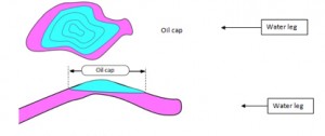
To find out the above, the geoscientist has to provide a visual aid representing the system on a surface and section. Figure 1 shows an oil pool on a map and on a section. The producible oil cap is shown, and the water level below it.
Exploration geophysicist provide the maps, by carrying out data acquisition campaigns, processing them to create down hole seismic imageries. These images are interpreted by geologists and the team work together to use them to drill explorations well alongside drillers and reservoir engineers.
How do we know oil and gas is in there?
In the early days of exploration, oil seeps to the surface were a major indication of presence of hydrocarbon. Today the use of seismic data with identifiable oil signatures in the amplitude serve as Direct Hydrocarbon Indicators (DHI). Other solution include statistics. You conclude on the presence of oil based on statistics showing that oil has been found often in such circumstances. There is always some level of uncertaintly until the first well is drilled.
Despite the exploitation of several basins in the world for petroleum, several regions of the world and marine still have untapped hydrocarbons. Environmental issues is limiting exploraiton in the artic and the oil industry is becoming keen in finding oil in areas where in areas where it will be less deteriorating for the environment. Exploration and production methods are therefore more strigent and requiring experienced geoscientist and engineers.
Exploration and Production Disciples
Exploration involves the use of seismic mapping and comparison exploration targets with those of well logs from offset (nearby) reservoirs, to evaluate the potential of the new prospects. Production starts after developing the field, involving planning and drilling the well. When production starts, follow up seismics (4D seismic) provide information that indicate the state of the remaining reserve of hydrocarbon resources. The resources are either conventional (insitu oil and gas) and unconventional hydrocarbons (heavy oil, oil shales, tar sand, shale gas and possibly gas hydrates). The extraction of heavy oil, tar sand and shale gas proves to be more challenging with respect to hazards to the environment.
The life of a given petroleum field is long, lasting for many years from the time of initiation of the project to the first result. Below are the different tools, methods and stages involved.
Exploration and appraisal
The aim of exploration and appraisal is to establish subsurface models, starting from geological cross-sections and horizon maps, to amplitude extractions from layers, to 3D blocks with wellpaths represented on them. Eventually a reservoir model is built to estimate potential reserves and extraction or recovery process.
Aerial photo, Remote Sensing, Modern Radar and Scanners
A first necessary stage of exploration is to capture the broad overview of the landscapes and geometries. Remote sensing refers to graphics and signals obtained from distance. Aerial photos are taken from aircrafts and images captured from satellites, which when interpreted provide a qualitative and quantitative geomorphology of the landscape or basin of interest. Modern day radar and spectral scans provide useful graphics in understanding the subsurface.
Geophysical methods
The most vital tool today in exploration and appraisal phase of hydrocarbon is geophysical. This ranges from basic methods such as magnetic and gravimetry surveying to advanced geophysical methods, including Seismic imaging (2D, 3D and 4D), including reflection and refraction technology and Vertical Seismic Profiling (VSP) which will be discussed in later chapters. An advanced method known as Seismic While Drilling attempt to predict pore pressure and depth matching solutions while drilling.
Well data, field sampling, and modeling
The exploration phase of petroleum geosciences uses well data from offset wells, fields sampling and modeling tools to explore and appraise propsetive oil fields. The idea is that if well close together has one of them producing in a given type of reservoir, pressure, etc, then the other well would likely be positive under the same conditions.
Development and Drilling
Drilling and completion
After exploration, the field is developed: logistical structures and piping to conduct eventually produced hydrocarbons are put in place and drilling commences. During the drilling phase, a geoscientist works with drillers to optimize formation evaluation and successful drilling of the well.
There are different types of drilling equipments, ranging from old cable-tool to present day rotary drilling bit attached in long pipes whose ensemble is known as Bottom Hole Assembly or BHA. The well is said to be completed when holes has been pieced across the protective casing or liner downhole and screens securely intalled, so that hydrocarbon fluid can flow from formation filtering through the small pieced holes into the well.
The Formation evaluation process
The first useful parameters for formation evaluation are the drilling parameters, including:
- Rotation of pipe (ROP)
- Rotation Per minute (RPM)
- Torque (TRQ)
Etc
They give indication of the rock type and how they react to intrusion, essentially for drilling safety. After this, the main formation evaluation, usually done before completion, involves the use of electrical, radioactive and other types of logs to measure rock and fluid properties either during (LWD) or after drilling the hole (Wireline). Among the logs used for formation evaluation are:
- Gamma ray
- Resistivity
- Sonic or acoustic
- Neutron-Porosity
- Bulk density
etc
The above helps the geoscientist to determine the rock type or lithology, and the fluid types, and how they behave downhole. These are important for estimating the hydrodcarbon reserve and completion procedures.
Production and management
Flowing the well
This starts when the well has been drilled and completed – flow is either natural or induced. Pressure mesuring equipment are installed for flow monitoring and provides information necessary for understanding the formation and for managing production throughout the life of the well. There are different production methods and well architectures are designed to meet their demandes.
Enhanced recovery
ight from the onset of produciton, but more frequently after an initial natural upsurge of hydrocarbon fluids, there’s need to maintain subsurface pressure and drive the upflow by an artificial means in order to enhance reocovery. Some of the Enhanced Oil Recovery (EOR) or drive processes are:
Water Drive (water is injected to pressure support the flow)
Gas Drive (cap drive when injected from the cap and dissolution drive where the modification of fluid properties due to gas injection enhances flow)
Acid cracking (dissolves acid soluble bonds, thereby reducing the viscosity of fluid and enhancing flow)
Borehole pressure reduction (a reduction in pressure on the upper part of the well will lead to vertical flow due to differencial pressure)
Well management
A petroleum well is managed right from the onset, and improved along the line based of flow monitoring result vis a vis unswept hydrocarbons; it may undergo processes known as reserve revision and addition, which are discussed later in this work.
All through the various stages of exploration and production, geologists, geophysicists, engineers; other professional such as accountants and doctors, work together to achieve success.
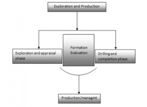
Schematic showing aspects of Exploration and Production